An Arizona Road Trip: Scenic Drives Sedona

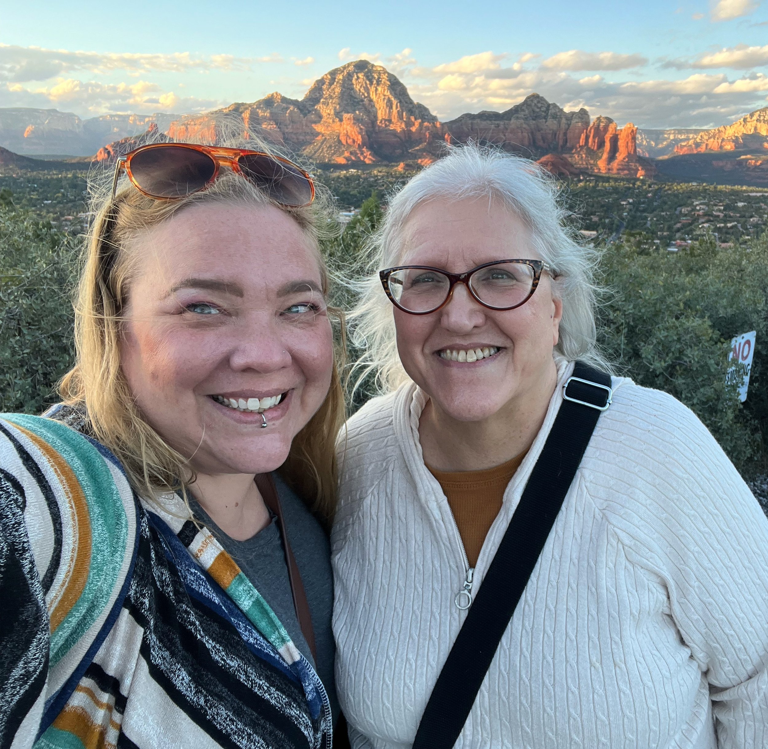
Red Rock views from Airport Mesa, Sedona, Arizona
This post contains affiliate links, which means I may receive a commission, at no extra cost to you, if you make a purchase through a link. This helps me keep the Sick Girl Travels blog running while providing you with high-quality product recommendations and great travel deals. Please see my full disclosure for further information. Thanks for your support!
My Road Trip to Sedona
Those of you who follow me on my socials might know my grandmother passed away earlier this year. She always had a special place in her heart for Sedona, Arizona, and adored the red rocks that make the area so famous. It was her final wish that her ashes be scattered there amongst those gorgeous red rock formations. As the traveler of the family and an ever-dutiful granddaughter with minimal social engagements to keep me tethered to Los Angeles, I volunteered to take her to her final resting place. So I packed up my bags and headed out from Los Angeles on a drive to Sedona for what was an epic Arizona road trip.
At this point, I feel compelled to say if you’re not a regular reader of my blog and just happened to come here for some excellent advice on what kind of scenic drives Sedona has to offer, rest assured I’m getting there. It’s not all a tear-jerking tale of how I carried an urn across the country from Wisconsin to Los Angeles and on to Sedona via Las Vegas. (Grandma always loved to travel.) But this is the backstory of how I came to take an epic road trip through Arizona, my grandma’s favorite place on Earth. I hope you fall in love with it as well.
Standing with my mom in front of grandma’s final resting place.
Why Sedona Rocks
Sedona, AZ is a desert town just south of Flagstaff known for its dramatic red-rock buttes, pine forests, and steep canyon walls. It’s one of the top 20 cities to visit on the USA’s west coast. It’s not only popular with adventure seekers looking to hike, climb, and camp amongst these gorgeous red rock formations, but also those looking for peaceful relaxation, spiritual enlightenment, arts, and culture, or chill scenic Sedona drives.
If you’d like to spend some time exploring the area, there are many great hotels in Sedona, several of which provide incredible views of the red rock formations.
The Sedona area is also known for its energy vortex sites. These Sedona energy vortex locations are spots where the earth’s energy is reportedly increased. Those who believe in them say they lead to increased self-awareness and various kinds of healing. I visited a few and thus far I’m sad to report there were no miraculous healing effects, but your mileage may vary. We’ll cover several below in our list of things to see in Sedona by car.
As someone with chronic pain and mobility issues, I found the great thing about Sedona is you don’t have to break your back hiking or climbing to see some of the most gorgeous sites. You can see many by just taking a scenic drive. But I’m here for you and got your back if you have your heart set on finding more adventurous things to do in Sedona.


Magnificent Sedona views
Sedona offers ample scenic viewpoints just off the highway. In fact, you may even find it difficult to concentrate while driving because the views just from the road are so breathtakingly gorgeous.
Some of the best views in Sedona are just off the highway and completely wheelchair accessible. And if you can’t drive it yourself there are most likely tours available. Check out Get Your Guide for the best wheelchair-accessible Sedona tours.

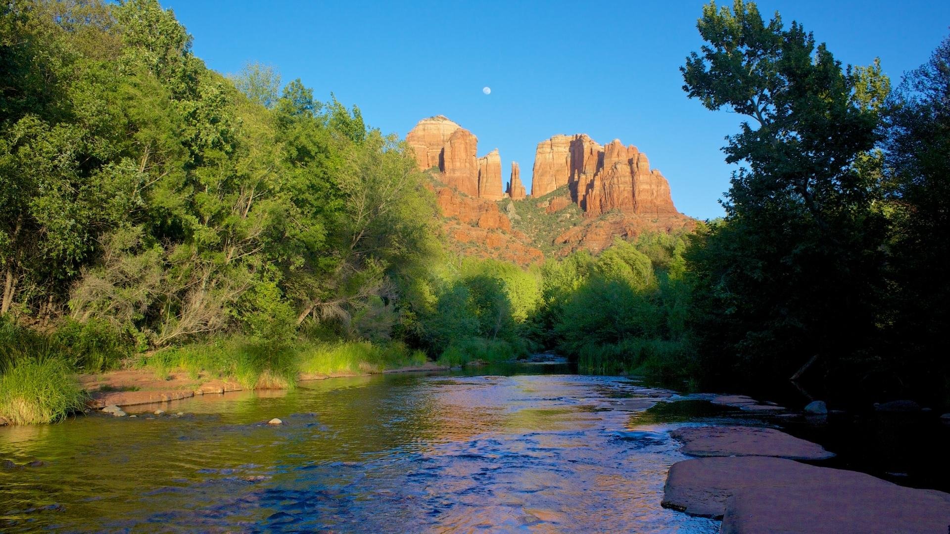
Dramatic red rock formations just off Highway 89a in Sedona, Arizona
Las Vegas to Sedona Road Trip
I started my road trip to Sedona in Las Vegas, Nevada, driving past the Hoover Dam heading south on US 93, then taking US 40 East to Flagstaff to US 17 South before reaching the incredibly scenic Highway 89a which brings you directly into Sedona. This is an approximately 4 1/2 hour drive spanning 280 miles.
State Route 89A will take you through the Verde Valley and into Coconino National Forest. If you’re looking to see some of that lush evergreen desert plants while winding through the canyons, this is the way to go.
It can get warm in Sedona, so if you’re traveling from April to October, make sure you appropriately pack for a summer road trip.
Phoenix to Sedona Road Trip
Another popular route into Sedona is to drive from Phoenix to Sedona. A Phoenix to Sedona Road Trip is just 2 hours and offers plenty of things to see along the way. On this route, you’ll take the I-17 North for 116 miles.

Desert plants heading south to Sedona through Coconino National Forest along State Route 89A.
Sedona Things to Do
There are so many unique things to do in Sedona and many can be seen from the comfort of your car without hiking up a mountain. Below I’ll cover some of my Sedona scenic drive highlights and tips for planning your own Sedona self-guided driving tour. Whether you’re spending a few days in Sedona or taking a quick Sedona day trip from Flagstaff, this guide will help you plan your trip. I’ll even include a few day trips from Sedona for even more driving adventures. So pack your bags and get ready to explore red rock country!
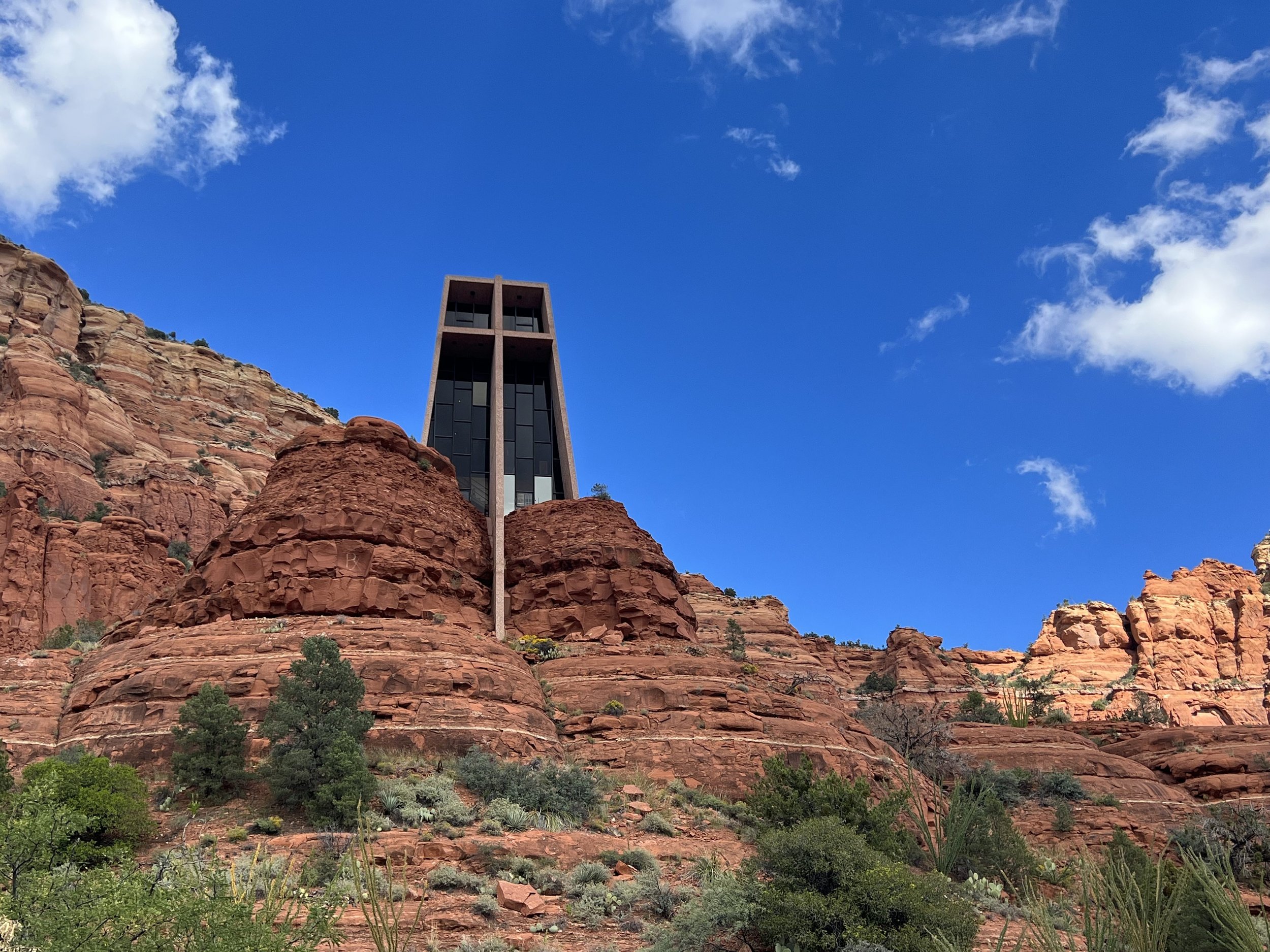
Chapel of the Holy Cross Catholic Church Sedona Arizona
Chapel of the Holy Cross
Amongst my favorite Sedona scenic drives is the trip to see the Chapel of the Holy Cross. From Highway 89A, take Highway 179 South toward the Village of Oak Creek. Turn left on Chapel Road and the Chapel of the Holy Cross will be at the end of the street.
Word of warning, parking can be incredibly difficult, and accessible parking spaces are really limited. When I visited we were unable to find a space. Still, you can take some great photos on the drive up the mountain by pulling off to the side of the road if traffic is slow. Please do not take photos while you are driving.
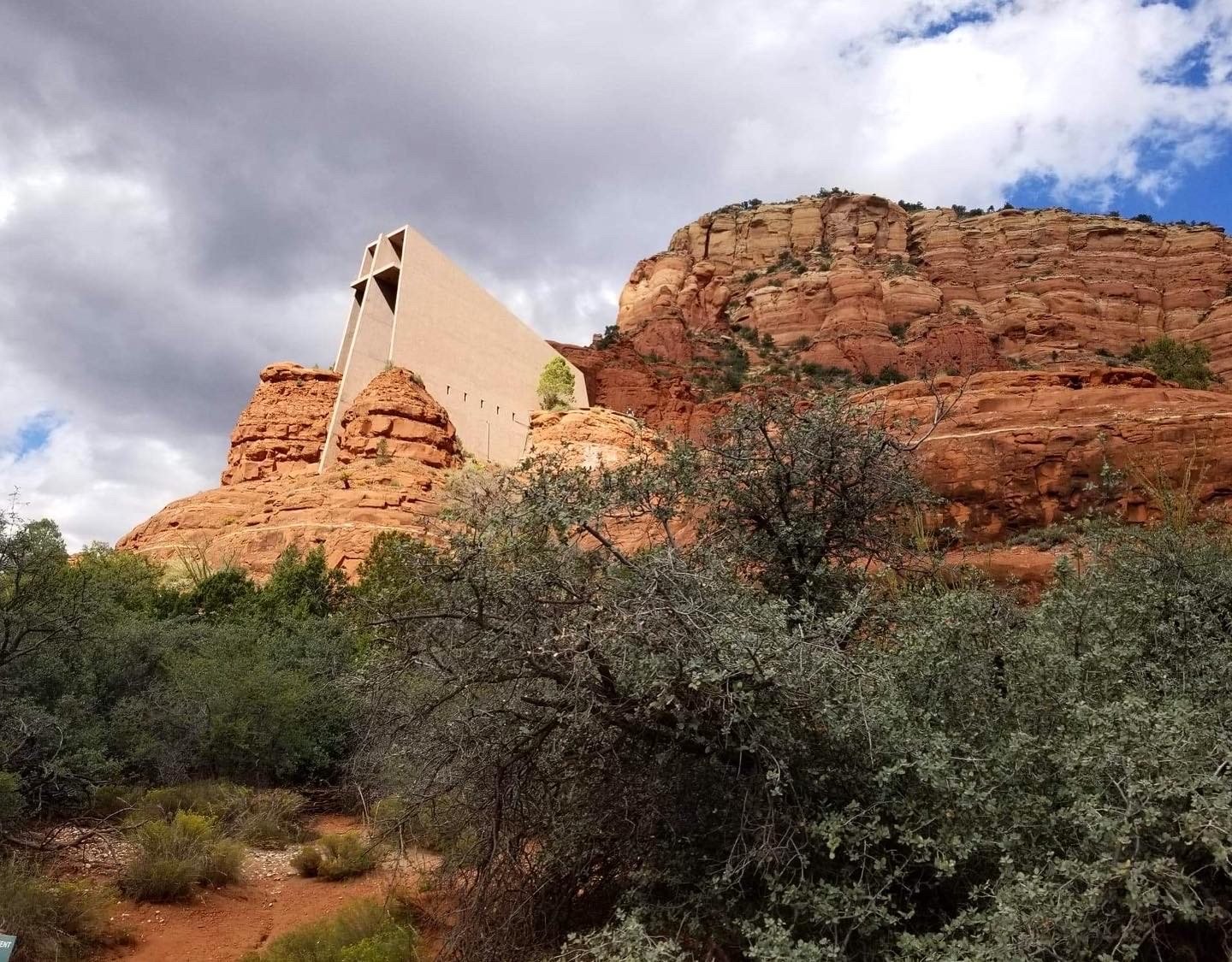
Side view of Chapel of the Holy Cross
Chapel of the Holy Cross is a Roman Catholic church built between the red rock buttes of Sedona, Arizona in 1956. In 2011 the chapel was added to the National Register of Historic Places. Though it is a Catholic church in faith, the chapel is viewed widely as a work of art and maintains a universal appeal. In 2007 Arizonans voted it to be one of the Seven Man-Made Wonders of Arizona.
The chapel is open to visitors and is accessible via a long concrete ramp.


Airport Mesa seen at Sunset. It’s one of the best places to sunset in Sedona.
Airport Mesa
If you’re looking for unparalleled red rock views and the best place to view a sunset in Sedona, look no further than Airport Mesa. To get to Airport Mesa, drive west from Uptown Sedona via Highway 89A for 1.1 miles. Turn left onto Airport Mesa Road and follow it for 1/2 a mile. The parking area will be on the left-hand side. Parking is $3 and allows you entrance all day so you can visit in the morning and come back for sunset for a completely different perspective.
The parking area is gravel, but the road outside is paved and offers space to take in the scenery. There is also a trail for those looking to hike. The trail leads to the Airport Mesa Vortex. As I am still recovering from my multiple spinal fusion surgeries and prone to rolling my ankles, I did not attempt a hike, other than to quickly dip a few feet down the mountain, surreptitiously scatter my grandmother’s ashes and silently say a few words before the parking attendant could notice.

Standing in front of the beautiful scenic overlook at Airport Mesa.
The hike does involve some vertical hiking, so it is not for everyone. However, for those able to make it you can enjoy one of Sedona’s energy vortexes. Many people even claim to see colored orbs. Be aware that the trail and site as a whole are particularly popular on weekends. If you’re looking for a less crowded experience, or to scatter the ashes of a loved one in private, I suggest going early. For the best-maintained trail, follow the signs from the parking lot labeled “Overlook.”
Warning, While the trail is short, it is steep. Hiking boots are strongly recommended.

Bell Rock Sedona, AZ
Bell Rock
One of the more famous rock formations in Sedona, Bell Rock is also a popular hiking destination. With an elevation of 4,919 feet, you can see Bell Rock from State Route 179 just north of the Village of Oak Creek, Arizona, just west of Courthouse Butte. It’s easy enough to pull off the road to snap a few pictures.
If you’re looking to hike Bell Rock, the most popular route involves a moderate hike that reaches a small plateau on the northwest face of the butte. A challenging unmarked trail is the only way to reach the summit. Considering I am in the physical shape to do neither, my photos were taken from Red Rock Loop Road. (More on that below.)
To reach Bell Rock coming from the Village of Oak Creek, drive north on Highway 179. Turn Right on Bell Rock Boulevard to access the main trailhead.

Views from car along Red Rock Loop Road
Red Rock Loop Road
This 13-mile loop will take you to some of the most beautiful parts of Sedona accessible either in your vehicle or by bike. The upper part of the loop is located off State Route 89A approximately 1 mile south of Sedona. Word of caution, Red Rock Loop Road is paved except for the last mile. This later part of the loop is unpaved and can become muddly and slippery when wet. Use caution if conditions have been rainy.
Red Rock State Park Red Rock formations
The loop spans 13 miles roundtrip and offers several trailheads and scenic stops, including views of Cathedral Rock, Courthouse Butte, and Bell Rock. You can also check out the Crescent Moon Picnic Area Red Rock Crossing (below) and Red Rock State Park, with its many hiking trails. Or you can view it all from the comfort of your car and the scenic overlook areas.
If you’re looking to camp, head into Red Rock State Park. The Ricardo Campground has 4 accessible campsites. The restrooms near the campsites are all wheelchair accessible.
The Red Cliffs day-use area offers 2 accessible picnic sites with accessible restrooms.
Red Rock Crossing
Red Rock Crossing is quintessential Sedona. It’s served as inspiration for musicians, filmmakers, artists, and visitors for many years. It’s also one of the most photographed areas of Sedona.
To get here, start at the intersection of Highway 89A and Highway 179 then drive west on Highway 89A through West Sedona. Turn left on Upper Red Rock Loop Road, drive 1.5 miles and follow signs for Red Rock Crossing.
It costs $9 to park at the Crescent Moon Picnic area. The parking lot includes two van-accessible spaces for guests with disabilities.

Montezuma Castle National Monument set against perfect blue skies.
Montezuma Castle National Monument
Yes, The United States has castles and this one dates back to somewhere between 1100 and 1425 AD. Montezuma Castle National Monument was one of the first national monuments in the United States. Established in 1906, it’s dedicated to preserving Native American Culture and the history of the Sinagua people. It’s also one of eight places to see Indian ruins in Arizona. I highly recommend making the drive to visit the castle.
As a National Park property, it is wheelchair accessible and accepts the National Parks Access Pass. If you are disabled and do not have a National Parks Access Pass click the link and sign up for yours now!

Beaver Creek located alongside Montezuma Castle National Monument
To get to Montezuma Castle National Monument drive south from Sedona along I-17 to exit 289, then drive east for 1/2 a mile and turn left onto Montezuma Castle Road. The park is located at 2800 Montezuma Castle Road Camp Verde, AZ 86322.
To see the castle guests need only traverse a short 1/3 mile paved trail which leads to the archeological remains and a small picnic area. Once at the site, you can observe this incredible prehistoric pueblo cliff dwelling. The 50-room pueblo ruin was excavated in 1933 uncovering a wealth of artifacts and greatly enhancing understanding of the Sinagua people who called this area along Beaver Creek home for over 400 years.

Striped walls of Antelope Canyon
Antelope Canyon
If you’re looking for a longer scenic adventure, I recommend this 3-hour drive north of Sedona, near Grand Canyon National Park.
Antelope Canyon is a slot canyon located on Navajo land east of Lechee, Arizona. It includes 5 distinct scenic slot canyon sections on the Navajo Reservation referred to as Upper Antelope Canyon, Owl Canyon, Mountain Sheep Canyon, Rattle Snake Canyon, and Lower Antelope Canyon. The most frequently visited by tourists is the Upper Canyon, also called The Crack. it remains the most popular because the entrance and exit are both at ground level requiring no climbing. The light also beams into the canyon year-round making it more consistently colorful than other sections of the canyon.
The Canyon is accessible only by guided tour. For tickets and a tour from Sedona check out the Antelope Canyon and Horseshoe Bend Tour From Sedona.

Stunning views of Grand Canyon National Park
Grand Canyon National Park
Is it even an Arizona road trip if you don’t visit the Grand Canyon? I think not. The south rim of Grand Canyon National Park is a little over 2-hours drive north of Sedona and makes a fantastic day trip.
The route along scenic Highway 180 is recommended for the wide variety of landscapes, ranging from towering mountains and massive pine forests to wide-open, high desert plains with Pinon Pines. Parts of this road can get busy and are limited to single-lane sections with limited passing opportunities, so be prepared to relax and enjoy the scenery.
If you’re not looking to drive yourself, you can opt to take a Small Group Tour From Sedona to the Grand Canyon.
Another option is to take the train from Williams, Arizona to the Grand Canyon. Train carriages dating back to 1901 have been restored to their original glory and offer riders a scenic trip through the forested areas and desert plains of Arizona winding through the countryside and ending up at the South Rim railway station. For tickets and more information head to Grand Canyon Railway Train Tickets.

The Seven Sacred Pools (or at least the 5 that would fit in the picture)
Seven Sacred Pools Sedona
If you’re into spirituality and mysticism and you’re a fully able-bodied person, then the Seven Sacred pools are a must-see stop on your Sedona road trip. I’m actually none of these things, but I’m including them on my list as they’re a fairly famous Sedona landmark. Unfortunately, The Seven Sacred Pools are only accessible via Soldiers Pass Trail, a 2 1/2 mile hike that takes about an hour and twenty minutes to complete. Sadly, as I am in no physical condition to hike Soldier Pass, I have to admire the pools in photos and videos.
The Seven Sacred Pools are a series of natural pools that descend down the red rocks. They were considered sacred by the Apaches and Yavapai and provided drinking water year-round in a barren desert. They’re now popular with many seeking spiritual enlightenment.


Cathedral Rock, Sedona, AZ
Cathedral Rock
Cathedral Rock is another site that’s fortunately fairly visible from Sedona scenic route 179. To drive to this rock formation is next to impossible as the road is generally closed to everyone but shuttles. The parking lot fills up as early as 6:30 am. But fear not! You can grab one of the trailhead shuttles serving Cathedral Rock and Little Horse from the North State Route 179 park and ride lot located at 1294 State Route 179. Just know that you will need to obtain a Red Rock Pass to visit the site.
Again, hiking isn’t my thing given my mobility issues, but if you’re interested in hiking Cathedral Rock, know that it’s a 1.2-mile hike round trip. It’s also one of the one of the most popular hikes in Sedona, so expect crowds. The total ascent is 700 feet, giving it a moderate level of difficulty. The total length of time to hike Cathedral Rock is 1 to 2 hours.

Beautiful Slide Rock State Park
Slide Rock State Park
Slide Rock State Park is a 14-minute drive north of Sedona on State Route 89A. The park was originally the Pendley Homestead but is now a 43-acre apple farm located within Oak Creek Canyon. The park gets its name from the natural water slide formed by the slippery bed of Oak Creek.
The park also offers trout fishing, wildlife and bird watching, a swimming hole and natural water slide, picnic areas, homestead exhibits, and a gift shop/ park store.
There are two modern ADA-accessible restroom buildings with sinks and a drinking fountain which are located above. the creek.
For more information about Slide Rock State Park, check out their website.
Oak Creek Vista
Along State Route 89A 13 miles north of Sedona in Coconino National Forest, you’ll find a fantastic scenic overlook called Oak Creek Vista. Do not pass up this view before heading south into Oak Creek Canyon. It’s a great spot for snapping photos high above the treetops.
The area is also known for its shopping, in particular Native American jewelry and other craft items from local Native American artists who set up their displays along the pathways.

Red Rocks at Oak Creek Canyon
Oak Creek Canyon
Oak Creek Canyon in the Sedona Verde Valley is an 8-minute scenic drive north of Sedona on State Route 89A. Known for its colorful rocks and unique formations, the canyon is famous for its picturesque scenery and is known as the smaller cousin of the Grand Canyon.
This spectacular 16-mile gorge offers streams and beautiful waterfalls between sheer rock walls. State Route 89 A enters the canyon on its north end and snakes through a series of winding curves for 13 miles before emptying out in the town of Sedona.
The depth of the canyon ranges from 800 to 2,000 feet. Oak Creek, a tributary of the Verde River flows through the bottom of the canyon.
If you’re driving to Sedona from the north you will have to pass through Oak Creek Canyon. I would strongly advise doing so during daylight hours as the turns can be quite hairpin and as of this writing, the road was under construction, adding an extra level of difficulty when driving.

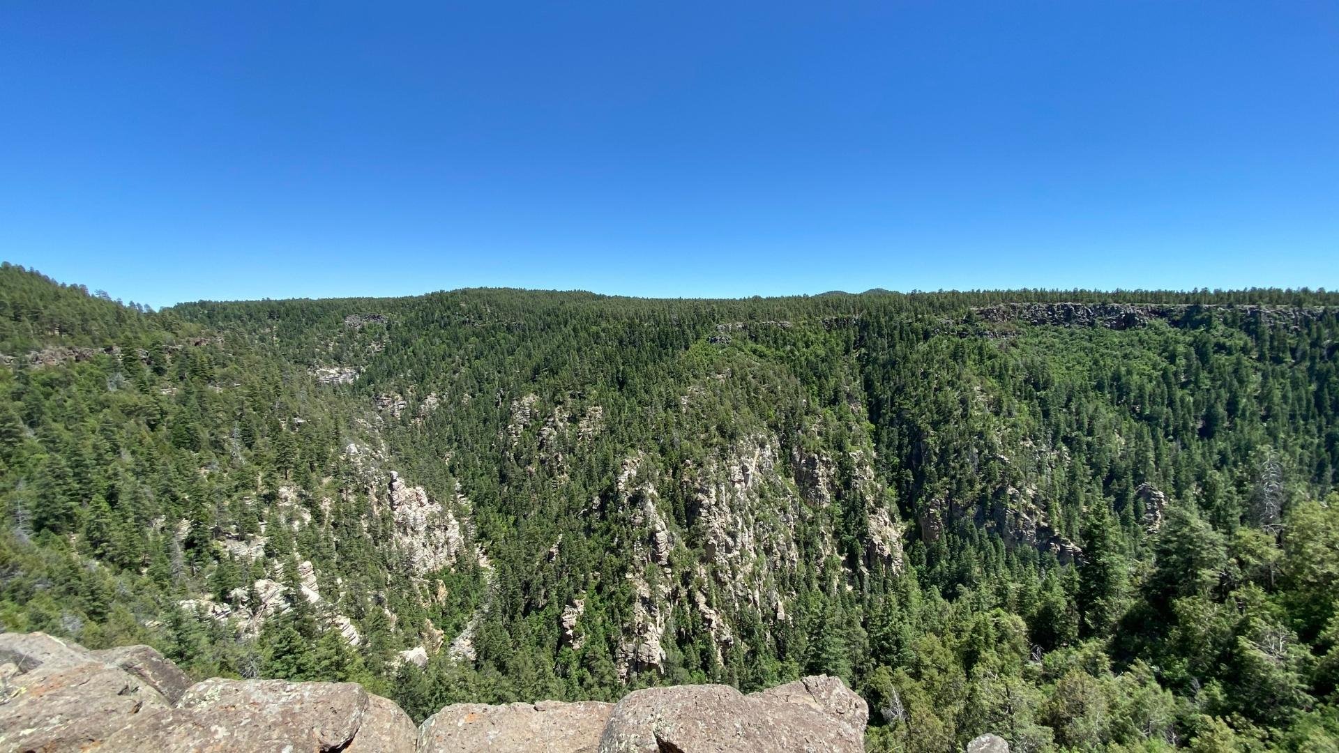
Coconino National Forest
Coconino National Forest
Having driven in from Las Vegas, I had to pass through Coconino National Forest to get into Sedona and let me say, the area is nothing short of breathtaking. It’s a prime location for those looking to camp, hike, and enjoy other outdoor activities. But if you’re not up to those things, it also makes for a gorgeous scenic drive.
Coconino also has a wheelchair-friendly trail, Oak Creek Trail, a 1.3 mile out and back trail. This trail is rated easy and takes an average of 25 minutes to complete. So if you are looking to do some hiking in the Sedona area and have physical limitations, this is a fantastic hiking option.
Devil’s Kitchen Sinkhole
For a more difficult trail, check out Soldier Pass Trail which takes 2.5 hours to complete and has a 400-foot elevation change. The trail takes you past Devil’s Kitchen Sinkhole and onto the Seven Sacred Pools.
For an even bigger challenge, try the West Fork Trail which is rated moderate, but spans 6.4 miles round trip and takes a whopping 3 1/2 hours to complete. (Or all day if you’re me.)


Head north to the city of Flagstaff
Flagstaff
For less expensive accommodations and close proximity to many of the Sedona area attractions, head north to the city of Flagstaff.
Flagstaff is known as Arizona’s winter wonderland, with an average snowfall of 108”. In spring visitors can enjoy a variety of blooms in the world’s largest contiguous emerald green pine forest. Flagstaff is also home to fantastic breweries, multiple pet-friendly patios, and over 200 mouth-watering restaurants.
For more information on planning your Flagstaff trip, check out the Flagstaff, Arizona website.

Fall Foliage of Kaibab National Forest
Kaibab National Forest
An hour and 15-minute drive northwest of Sedona, Kaibab National Forest surrounds the Northern and Southern portions of the Grand Canyon. Kaibab offers canyons, peaks, prairies, plateaus, and everything in between. At 1.6 million acres it’s impossible to take it all in, but if you’re making the drive to Grand Canyon National Park, it should definitely be on your must-see list.

Tuzigoot National Monument
Tuzigoot National Monument
Tuzigoot National Monument is a half-hour drive southwest of Sedona via Highway 89A. The monument is a multi-room pueblo ruin on the summit of a limestone and sandstone ridge similar to others in the Verde Valley region. Tuzigoot is a Tonto Apache term for “crooked waters” a reference to the Verde River leading out from nearby Pecks Lake.
The pueblo is estimated to have been built by the Sinagua people between 1125 and 1400 AD making it part of one of the oldest cities in America. Tuzigoot is the largest and best preserved of the Sinagua pueblo ruins within the Verde Valley.

Views from Red Rock Scenic Byway
Red Rock Scenic Byway
Red Rock Scenic Byway is one of the most popular drives in Sedona. The byway begins on State highway 179 at the Highway Bridge crossing Dry Beaver Creek (tee hee) and dead ends at Highway 89 A. If you’re staying in Sedona, you most likely have to traverse this section of the road at some point. Pro tip: following the Little Horse Trailhead, there is a scenic pull-out and parking area to take in the amazing views.
The Red Rock Scenic Byway is about 14 1/2 miles from start to finish, with non-stop great views the entire way.

Scenic Canyon Views off Dry Creek Road.
Dry Creek Road
A relatively short, partly paved loop just off State Route 89A provides access to the area, taking you past trails, canyons, and expansive mountain vistas. Word of warning, because this road is only partially paved, it does have a small stretch that is bumpy and can be uncomfortable for low-slung cars.
A popular start to this drive is breakfast at Coffee Pot Restaurant, located at 2050 W. State Route 89A. This tasty breakfast spot gets its name from the rock formation directly behind the restaurant which looks like an old-fashioned percolator.
Like other scenic drives in Sedona, there are several hiking locations located nearby. The most popular along Dry Creek Road is Devil’s Bridge. This hike is a little less than a mile with a gain of about 400 feet in elevation. The trail is rated as fairly easy.

Scenic driving along Highway 179, Sedona, Arizona.
I Hope You’ve Enjoyed This List of Sedona, AZ Things to Do
As you can see there are tons of scenic drives Sedona has to offer. Hopefully, you have more than enough to plan your own amazing Arizona road trip. If you have any suggestions to add or questions about the drives and sites above, feel free to leave a comment below.
Happy travels!